Introduction of surveying
Definition of surveying- Surveying is the art of making such measurements as will determine the relative positions of points on the surface of the earth in order that the shape and extent of any portion of earth's surface may be ascertained and delineated on a map or plan. It is essentially a process of determining positions of points in a horizontal plane.

Leveling- is the art of determining and representing the relative heights or elevations of different points on the surface of the earth. It is the process of determining positions of points in a vertical plane.
The surveying may primarily be divided into the following two types :
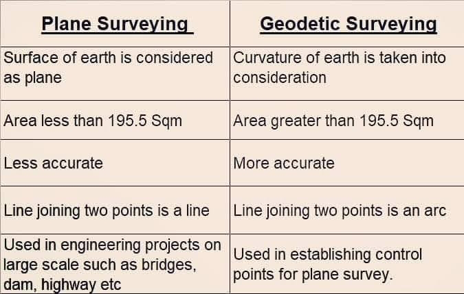
1) Plane Surveying :- The surveys in which the curvature of earth is not taken into consideration are known as plane surveys. These surveys extend over small areas. The degree of accuracy obtained in this type of surveying is comparatively low. Generally areas less than 250 km² are treated as plane When the surveys extend over limited areas, the difference in length between the are and the subtended chord for any two points on the surface of the earth is only about 0.1 m for a distance of 18.2 km, 0.3 m for 54.3 km and 0.5 m for 91 km. Similarly, the difference between the sum of the angles of a spherical triangle on the earth's surface and that of the angles of the corresponding plane triangle is only one second for every 195.5 km*2 of area.
2) Geodetic Surveying :- Geodetic surveying. The surveys in which the curvature of earth is taken into consideration are known as geodetic surveys (also called trigonometrical surveying). These surveys extend over large areas (more than 250 km) and where the degree of accuracy required is great.
General Classification of Surveys :-
The surveys may be classified in different ways as follows:
1. According to the instrument used :- The surveys, according to the instrument used are chain survey, compass survey, plane table survey, theodolite survey etc.
2. According to the purpose of survey :- The surveys, according to the purpose are mine survey, geological survey, archacological survey and military survey.
3. According to the method employed :- The surveys, according to the method employed are triangulation survey and traverse survey
4. According to the place of work :- The surveys, according to the place of work are land survey, hydrographical or marine survey and aerial survey.
The land survey may be further sub-divided into the following classes:-
(a) Topographical survey. This survey is carried out for determining the natural features of the country such as hills, valleys, rivers, lakes, woods and nallahs etc. It is also used for artificial objects such as canals, railways, roads, towns and villages etc.
(b) Cadastral survey. This survey is performed to determine the additional details such as boundaries of fields, houses and other property.
(c) City survey. This survey is performed in connection with town planning schemes such as drainage, water supply etc, and for laying our plots, roads, streets etc.
(d) Engineering survey. This survey is performed for determining and for collecting data for the design of engineering works such as roads, railways, reservoirs or works in connection with water supply, sewerage etc.
The engineering survey may be further sub-divided into the following classes:-
(1) Reconnaissance surveys for determining the feasibility and rough cost of scheme.
(2) Preliminary surveys for collecting more precise data to choose the best location for the work.
(3) Location surveys for setting out the work on the ground.
Uses of Surveys :- Surveying may be regarded as an art and science of map making. The arts of surveying and mapping have been practiced from very ancient times and their application has become increasingly important as time has progressed. The earliest surveys were chiefly confined to measurement of land and establishment of boundaries. The engineer must be thoroughly familiar with the principles and practice of surveying. since all engineering and construction projects extending over large areas, such as highways, railways, irrigation, water supply, etc., are based upon elaborate and complete surveys. In all Engineering projects the preparation of accurate plans and sections is the first necessity.


Comments
Post a Comment